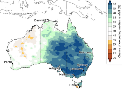
The remainder of September is likely to be warmer than average across most of Australia, with roughly equal chances of warmer or cooler days and nights on parts of the south coast, according to the Bureau of Meteorology. Rainfall in the second half of September is likely to be average to above average across the country.
The remainder of the year is likely to see above average rainfall across much of the eastern two thirds of the country for the remainder of the year. Parts of northern WA and western Tasmania are likely to be drier than average.
October to December days are likely to be warmer than average across northern Australia, and the far south-east. Nights during October to December are very likely to be warmer than average across most of Australia, except south-west WA.
The Bureau's ENSO Outlook is at La Niña ALERT, meaning there is at least a 70% chance of La Niña forming in 2020. The Indian Ocean Dipole (IOD) index has been at negative IOD values for three of the last four weeks; some models suggest a weak/borderline event may develop in spring. La Niña and a negative IOD typically increase the likelihood of above average spring rainfall across much of Australia.
